RELATIONSHIP BETWEEN RAINFALL AND LAND COVER ON THE NUMBER OF HOTSPOTS IN LORE LINDU NATIONAL PARK

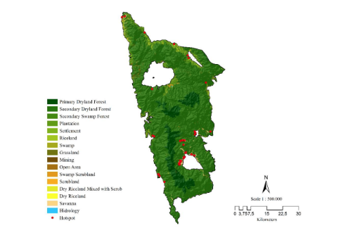
Forest and land fires in Indonesia need concern in handling it, specifically in conservation areas. Lore Lindu National Park (TNLL) is a conservation area that plays a role in preserving endemic plants and animals and their habitats. Research on the factors that influence forest fires in TNLL needs to be carried out to protect and prevent the risk of forest fires to protect the ecosystem. This study aims to analyze the relationship between rainfall and land cover on the number of hotspots as an indicator of forest fires in TNLL in 2017-2021. Thus, preventive strategies can be carried out as early as possible to prevent forest fires. This research was conducted by analyzing spatially and statistically 2017-2021 rainfall data in Sigi and Poso Regencies, hotspot data from the TERRA/AQUA, SNPP, and MODIS-NASA satellite in 2017-2021 in TNLL, and TNLL land cover data. In statistical analysis, rainfall data for hotspots was analyzed using Bivariate Pearson, and land cover data for hotspots was analyzed spatially using ArcMap. The results showed 55 hotspots in TNLL from 2017-2021. The Bivariate Pearson correlation test results between rainfall and hotspots are -0.028. The relationship between rainfall and hotspots shows a non-directional correlation. The lower the rainfall intensity, the more hotspots are found. Spatially, the highest number of hotspots occurred in areas with the land cover of secondary dryland forest types, with a total of 29 spots.
Downloads
Aflahah E, Hidayati R, Hidayat R, Alfahmi F. 2019. Pendugaan hotspot sebagai indikator kebakaran hutan di Kalimantan berdasarkan faktor iklim [Hotspot asummption as a forest fire indicator in Kalimantan based on climate factor]. Jurnal Pengelolaan Sumberdaya Alam dan Lingkungan (Journal of Natural Resources and Environmental Management). Bogor, ID, 9(2), pp. 405-418. doi: 10.29244/jpsl.9.2.405-418.
Ananda FR, Purnomo EP, Fathani AT, Salsabila L. 2022. Strategi pemerintah daerah dalam mengatasi kebakaran hutan dan lahan di Kabupaten Kotawaringin Barat [Regional government strategy in dealing with forest and land fires in West Kotawaringin Regency]. Jurnal Ilmu Sosial Dan Humaniora, 11(2), 1 73-181. DOI: https://doi.org/10.23887/jish.v11i2.34698
Badri M, Lubis DP, Susanto D, Suharjito D. 2018. Sistem komunikasi peringatan dini pencegahan kebakaran hutan dan lahan di Provinsi Riau [Early warning communication system for preventing forest and land fires in Riau Province]. Jurnal PIKOM (Penelitian Komunikasi Dan Pembangunan), 19(1), 1-16. DOI: https://doi.org/10.31346/jpikom.v19i1.1266
Cochrane M. 2013. Current fire regimes, impacts and likely changes-V: Tropical South America. In: J. G. Goldammer (ed.) Vegetation fires and global change: Challenges for concerted International action. A white paper directed to the United Nations and international organiz. Germany: Kessel House.
Dini NLK, Jauhari A, Rachmawati N. 2022. Prediksi nilai karbon yang hilang akibat kebakaran hutan dan lahan di Kota Banjarbaru [Prediction of the value of carbon lost due to forest and land fires in Banjarbaru City]. Jurnal Sylva Scienteae, 5(3), 372-378. DOI: https://doi.org/10.20527/jss.v5i3.5708
Endrawati, Purwanto J, Nugroho S, Agung R. 2017. Identifikasi areal bekas kebakaran hutan dan lahan menggunakan analisis semi otomatis citra satelit landsat [Identification of areas where forest and land fires have occurred using semi-automatic analysis of Landsat satellite images]. Seminar Nasional Geomatika 2017: Inovasi Teknologi Penyediaan Informasi Geospasial Untuk Pembangunan Berkelanjutan, 273-282. DOI: https://doi.org/10.24895/SNG.2017.2-0.420
Fitria P, Jauhari A, Rianawati F. 2021. Analisis tingkat kerawanan kebakaran hutan dan lahan berbasis penginderaan jauh di Kecamatan Karang Intan [Analysis of the level of vulnerability to forest and land fires based on remote sensing in Karang Intan District]. Jurnal Sylva Scienteae, 4(6), 1110-1120. DOI: https://doi.org/10.20527/jss.v4i6.4614
Giglio L, Schroeder W, Justice CO. 2016. The collection 6 MODIS active fire detection algorithm and fire products. Remote Sensing of Environment, 178, 31-41. doi: 10.1016/j.rse.2016.02.054 DOI: https://doi.org/10.1016/j.rse.2016.02.054
Hadiyani F, Nurhayati A. 2022. Hotspot analysis in 2015 and 2019 at Ogan Komering Ilir district South Sumatra Province. IOP Conf. Series: Earth and Environmental Science, 959 012056 DOI: https://doi.org/10.1088/1755-1315/959/1/012056
Harrison ME, Page SE, Limin SH. 2009. The global impact of Indonesian forest fires. Biologist, 56(3), 156-163.
Indradjad A, Purwanto J, Sunarmodo W. 2019. Analisis tingkat akurasi titik hotspot dari S-NPP VIIRS dan TERRA/AQUA MODIS terhadap kejadian kebakaran [Analysis of the accuracy level of hotspot points from S-NPP VIIRS and TERRA/AQUA MODIS regarding fire events]. Jurnal Penginderaan Jauh Dan Pengolahan Data Citra Digital, 16(1), 53-60.
Jaya INS, Purnama ES, Arianti I, Jaruntorn B. 2007. Forest Fire Risk Assessment Model and Post-Fire Evaluation Using Remote Sensing and GIS: A Case Study in Riau, West Kalimantan And East Kalimantan Provinces, Indonesia. The Forest Restoration and Rehabilitation Training Course and Workshop, Viiki Tropical Resources Institute (VITRI), University of Helsinki, Finland.
Kementerian Lingkungan Hidup dan Kehutanan. 2016. Peraturan Menteri Lingkungan Hidup dan Kehutanan Nomor P.32/MenLHK/Setjen/ Kum.1/3/2016 tentang Pengendalian Kebakaran Hutan dan Lahan [Regulation of the Minister of Environment and Forestry Number P.32/MenLHK/Setjen/Kum.1/3/2016 concerning Control of Forest and Land Fires]. Jakarta: Kementerian Lingkungan Hidup dan Kehutanan.
Mulyono D. 2016. Analisis Karakteristik Curah Hujan Di Wilayah Kabupaten Garut Selatan [Analysis of Rainfall Characteristics in the South Garut Regency Area]. Jurnal Konstruksi 12(1), 1-9. doi: 10.33364/ konstruksi/v.12-1.274. DOI: https://doi.org/10.33364/konstruksi/v.12-1.274
Muzaki A, Pratiwi R, Az Zahro SR. 2021. Pengendalian kebakaran hutan melalui penguatan peran polisi kehutanan untuk mewujudkan sustainable development goals [Controlling forest fires through strengthening the role of forestry police to realize sustainable development goals]. LITRA: Jurnal Hukum Lingkungan, Tata Ruang, Dan Agraria, 1(1), 22-44. doi: 10.23920/litra.v1i1.579. DOI: https://doi.org/10.23920/litra.v1i1.579
Prabowo MR, Koesmaryono Y, Faqih A, Sopaheluwakan A. 2020. Karakteristik spasial dan temporal hotspot di Pulau Sumatera [Spatial and temporal characteristics of hotspots on Sumatra Island]. Jurnal Meteorologi dan Geofisika, 21(1), 9-19. doi: 10.31172/jmg.v21i1.674. DOI: https://doi.org/10.31172/jmg.v21i1.674
Prawaka F, Zakaria A, Tugiono S. 2016. Analisis data curah hujan yang hilang dengan menggunakan metode normal ratio, inversed square distance, dan rata-rata aljabar (studi kasus curah hujan beberapa stasiun hujan daerah Bandar Lampung [Analysis of missing rainfall data using the normal ratio, inverse square distance, and algebraic average methods (case study of rainfall at several rainfall stations in the Bandar Lampung area)]. Jurnal Rekayasa Sipil Dan Desain, 4(3), 397-406.
Putra EI, Husni RF. 2021. Hubungan curah hujan dan titik panas (hotspot) kebakaran di Hutan Lindung Gambut (HLG) Londerang, Provinsi Jambi [Relationship between rainfall and fire hotspots in Londerang Peat Protection Forest (HLG), Jambi Province]. Journal Silvikultur Tropika, 12(3), 129-134. DOI: https://doi.org/10.29244/j-siltrop.12.3.129-134
Rasyid, Fachmi. 2014. Permasalahan dan Dampak Kebakaran Hutan [Issues and Impacts of Forest Fires]. Jurnal Lingkar Widyaiswara, 1(4), 47-59.
Saharjo BH, Nasution MRA. 2021. Pola sebaran titik panas (hotspot) sebagai indikator terjadinya kebakaran hutan dan lahan di Kabupaten
Aceh Barat [Hotspot distribution patterns as an indicator of forest and land fires in West Aceh District]. Journal Silvikultur Tropika, 12(2),
-66. doi: 10.29244/j-siltrop.12.2.60-66. DOI: https://doi.org/10.29244/j-siltrop.12.2.60-66
Saputra MR, Arisanty D, Adyatma S. 2021. Tingkat kerawanan kebakaran hutan dan lahan di Banjarbaru Provinsi Kalimantan Selatan [Land and forest fire vulnerability in Banjarbaru, South Kalimantan Province]. Jambura Geoscience Review, 3(2), 57-64. doi: 10.34312/jgeosrev.v3i2.5648 DOI: https://doi.org/10.34312/jgeosrev.v3i2.5648
Sinaga RP, Darmawan A. 2014. Perubahan tutupan lahan di Resort Pugung Tampak Taman Nasional Bukit Barisan Selatan (TNBBS) [Land cover change in the Pugung Resort of Bukit Barisan Selatan National Park (TNBBS)]. Jurnal Sylva Lestari, 2(1), 77-86. DOI: https://doi.org/10.23960/jsl1277-86
Syaufina L. 2008. Kebakaran Hutan dan Lahan di Indonesia: Perilaku Api, Penyebab, dan Dampak Kebakaran [Forest and Land Fires in Indonesia: Fire Behaviour, Causes, and Impacts]. Malang: Bayumedia Publishing.
Syaufina L, Hafni DAF. 2018. Variabilitas iklim dan kejadian kebakaran hutan dan lahan gambut di Kabupaten Bengkalis, Provinsi Riau [Climate variability and the incidence of forest and peatland fires in Bengkalis Regency, Riau Province]. Jurnal Silvikultur Tropika 9(1): 60-68. DOI: https://doi.org/10.29244/j-siltrop.9.1.60-68
Syaufina L, Sukmana A. 2008. Tinjauan Penyebab Utama Kebakaran Hutan Di Daerah Tangkapan Air Danau Toba. In Pusat Penelitian dan Pengembangan Hutan Konservasi Alam. Pusat Penelitian dan Pengembangan Hutan Konservasi Alam [Review of the Main Causes of Forest Fires in the Lake Toba Catchment Area. In Centre for Research and Development of Nature Conservation Forests. Centre for Research and Development of Nature Conservation Forests]. https://www.academia.edu/download/ 34834904/Fire_causes_at_catchment_area_of_Toba_Lake.pdf
Utomo AW, Suprayogi A, Sasmito B. 2017. Analisis hubungan variasi Land Surface Temperature dengan kelas tutupan lahan menggunakan data citra satelit landsat (Studi kasus: Kabupaten Pati) [Analysing the relationship between Land Surface Temperature variation and land cover class using landsat satellite image data (Case study: Pati District)]. Jurnal Geodesi Undip, 6(2), 71-80.
Yusuf A, Hapsoh, Siregar SH, Nurrochmat DR. 2019. Analisis kebakaran hutan dan lahan di Provinsi Riau [Analysis of forest and land fires in Riau Province]. Dinamika Lingkungan Indonesia, 6(2), 67-84. doi: 10.31258/dli.6.2.p.67-84. DOI: https://doi.org/10.31258/dli.6.2.p.67-84
Copyright (c) 2024 Fadjri Maarif, Cesar Andi Mappatoba

This work is licensed under a Creative Commons Attribution-NonCommercial-NoDerivatives 4.0 International License.
Authors who publish with this journal agree with the following terms:
- Authors retain copyright and grant the journal right of first publication, with the work 1 year after publication simultaneously licensed under a Creative Commons attribution-noncommerical-noderivates 4.0 International License that allows others to share, copy and redistribute the work in any medium or format, but only where the use is for non-commercial purposes and an acknowledgement of the work's authorship and initial publication in this journal is mentioned.
- Authors are able to enter into separate, additional contractual arrangements for the non-exclusive distribution of the journal's published version of the work (e.g., post it to an institutional repository or publish it in a book), with an acknowledgement of its initial publication in this journal.
- Authors are permitted and encouraged to post their work online (e.g., in institutional repositories or on their website) prior to and during the submission process, as it can lead to productive exchanges, as well as earlier and greater citation of published work (See The Effect of Open Access).