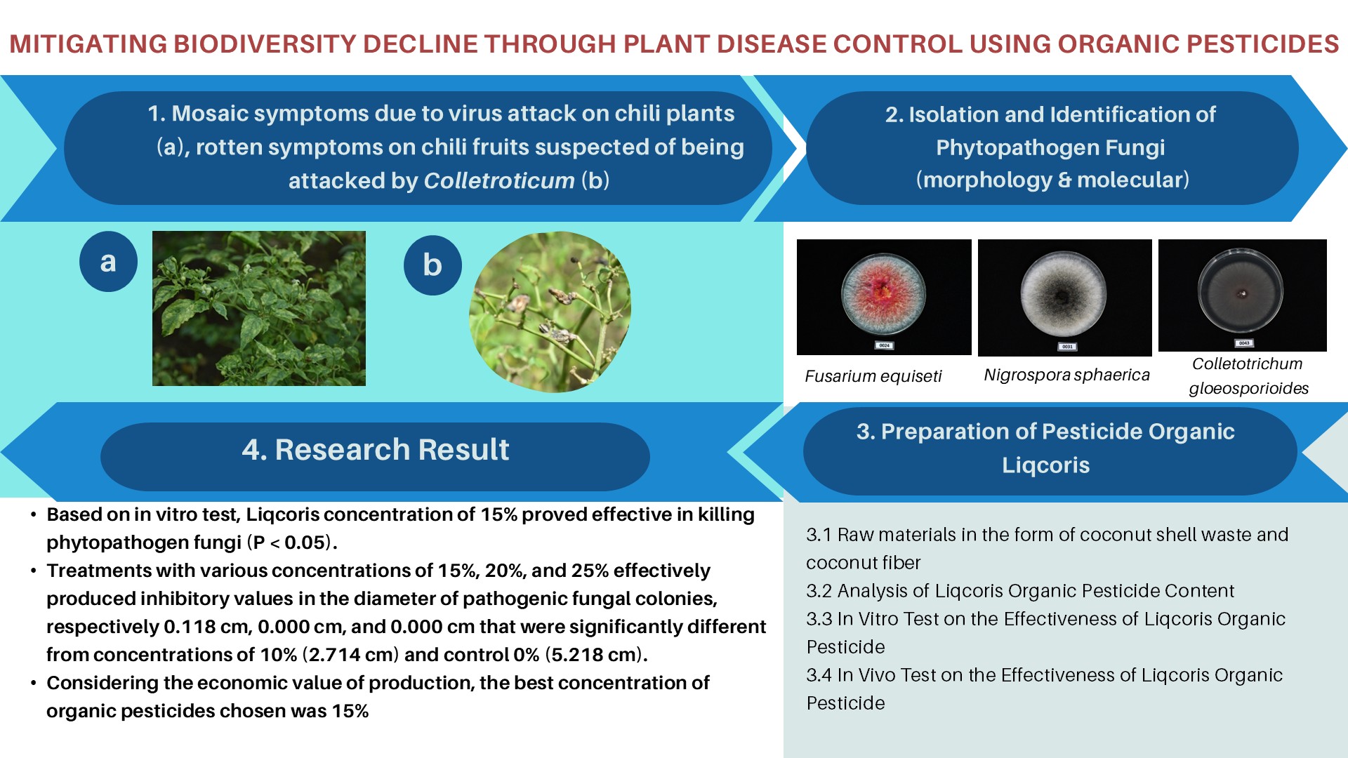
ASSESSMENT OF SPOT SATELLITE DATA FOR TROPICAL VEGETATION INVENTORY AND MONITORING IN SUMATRA

Downloads
Following a previous vegetation mapping in Sumatra island (Indonesia), an assessment of SPOT satellite capability to handle specific problems related to vegetation identification and monitoring from remote sensing data has been undertaken. Results of visual interpretation and multispectral analysis have shown the usefulness of SPOT data for the appraisal of tropical vegetation at medium scale. This was particularly striking for the swampy vegetation types including mangroves and for the secondary vegetation, for which significant improvements have been brought by multispectral classifications. A 20 m ground resolution is neither sufficient to provide information on primary forest patterns, nor to identify properly logged over areas. Never theless, several degrees of depletion of the forest and all the serial stages have been identified, which is a considerable progress compared with previous remote sensing means. SPOT is a very good alternative to medium scale aerial photographs for the production of medium scale (1 : 100 000 to 1 : 250 000) vegetation and land-use maps.
Downloads
Copyright (c) 2017 BIOTROPIA - The Southeast Asian Journal of Tropical Biology

This work is licensed under a Creative Commons Attribution-NonCommercial-NoDerivatives 4.0 International License.
Authors who publish with this journal agree with the following terms:
- Authors retain copyright and grant the journal right of first publication, with the work 1 year after publication simultaneously licensed under a Creative Commons attribution-noncommerical-noderivates 4.0 International License that allows others to share, copy and redistribute the work in any medium or format, but only where the use is for non-commercial purposes and an acknowledgement of the work's authorship and initial publication in this journal is mentioned.
- Authors are able to enter into separate, additional contractual arrangements for the non-exclusive distribution of the journal's published version of the work (e.g., post it to an institutional repository or publish it in a book), with an acknowledgement of its initial publication in this journal.
- Authors are permitted and encouraged to post their work online (e.g., in institutional repositories or on their website) prior to and during the submission process, as it can lead to productive exchanges, as well as earlier and greater citation of published work (See The Effect of Open Access).